Miklat MCP Data: A Community-Driven Shelter Geodata Pipeline for Israel
A community-maintained data pipeline that collects, structures, and validates Israeli public shelter geodata for the Miklat MCP server.
The Project
https://github.com/danielrosehill/Miklat-MCP-Data
danielrosehill/Miklat-MCP-Data View on GitHubAfter building the Miklat MCP server to help AI agents find public shelters in Israel, I needed a clean way to manage the underlying geodata separately from the server code. Miklat MCP Data is that upstream data repository — a community-maintained pipeline that tracks 199 municipalities across Israel, with the goal of building a comprehensive public shelter dataset for the entire country.
danielrosehill/Miklat-MCP View on GitHubThe Four-Stage Pipeline
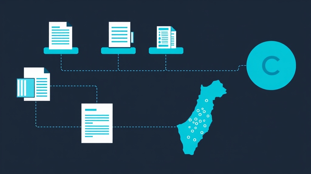
The repository implements a structured data pipeline designed for humans and AI agents to collaborate on. Data moves through four stages before it reaches the live MCP endpoint:
First Entry — Raw source material in any format: PDFs, spreadsheets, web scrapes, or CSV exports from municipal websites. Each of the 199 tracked areas has its own folder ready for contributions.
Structured — AI agents or human contributors process the raw data, geocode addresses, and convert it into the GeoJSON schema. This stage also includes a
shelter-resources.jsonmunicipal resource directory.Validated — Quality control checks for coordinate accuracy, schema conformance, and deduplication. This is the final gate.
Production — Validated data is promoted to the
data/folder and becomes available to the Miklat MCP server atmcp.jlmshelters.com/mcp.

The Data Schema and Manifest
Every shelter is stored as a GeoJSON Feature with properties including name, neighborhood, address, shelter type (Public Shelter, Protected Parking, School Shelter, etc.), capacity, accessibility status, and GPS coordinates. Newer fields like alertZone (Home Front Command zone) and deepestFloor add detail that matters during actual emergencies.
The data-manifest/manifest.json file serves as the ground truth for the entire project. It lists all 199 areas with unique identifiers (MKT-001 through MKT-199), Hebrew and English names, municipality type, district, population, and links to raw data sources. This manifest is what makes it possible to track progress across the entire country systematically. Currently, Jerusalem is the only city with production-ready data — the original dataset was sourced from the JLM-Shelters-Dot-Com project and is licensed under ODbL.
The national shelter map from GovMap is referenced as a key upstream source. If you're in Israel and have access to shelter data for your municipality, contributions via pull request are very welcome — even dropping raw PDFs or links into the first-entry stage is helpful.